![]()
Introduction to GLOBE Data#
We will examine two GLOBE datasets: Mosquito Habitat Mapper and Land Cover.
You can view an interactive dashboard of this data.
You can run the following code using Google Colab, which runs on your browser (no installations required).
First, we’ll load the Python packages, which gives us more options with our code.
import pandas as pd                           # For working with data
pd.set_option("display.max_columns", None)    # Lets us see all columns of the data instead of just a preview
import geopandas as gpd                       # For working with spatial data
import numpy as np                            # For working with numbers
import matplotlib.pyplot as plt               # For making graphs
from datetime import date                     # For formatting dates
from PIL import Image                         # For getting and displaying images from links
import requests                               # For getting information from links
from io import BytesIO                        # For working with types of input and output
end_date = "2024-12-31"
Mosquito Habitat Mapper#
Let’s use the GLOBE API, which allows us to get data directly without needing to download anything.
data = gpd.read_file(f"https://api.globe.gov/search/v1/measurement/?protocols=mosquito_habitat_mapper&datefield=measuredDate&startdate=2018-01-01&enddate={end_date}&geojson=TRUE&sample=FALSE")
If you get an error NameError: name 'gpd' is not defined, go to the top of this notebook and click the arrow next to the first code block starting with import geopandas as gpd. This will install the packages needed for the rest of the code.
View the first 10 rows of the data, which are the most recently collected entries submitted to the GLOBE Observer App.
data.head(10)
| countryCode | countryName | elevation | mosquitohabitatmapperAbdomenCloseupPhotoUrls | mosquitohabitatmapperBreedingGroundEliminated | mosquitohabitatmapperComments | mosquitohabitatmapperDataSource | mosquitohabitatmapperExtraData | mosquitohabitatmapperGenus | mosquitohabitatmapperGlobeTeams | mosquitohabitatmapperLarvaFullBodyPhotoUrls | mosquitohabitatmapperLarvaeCount | mosquitohabitatmapperLastIdentifyStage | mosquitohabitatmapperLocationAccuracyM | mosquitohabitatmapperLocationMethod | mosquitohabitatmapperMeasuredAt | mosquitohabitatmapperMeasurementElevation | mosquitohabitatmapperMeasurementLatitude | mosquitohabitatmapperMeasurementLongitude | mosquitohabitatmapperMosquitoAdults | mosquitohabitatmapperMosquitoEggCount | mosquitohabitatmapperMosquitoEggs | mosquitohabitatmapperMosquitoHabitatMapperId | mosquitohabitatmapperMosquitoPupae | mosquitohabitatmapperSpecies | mosquitohabitatmapperUserid | mosquitohabitatmapperWaterSource | mosquitohabitatmapperWaterSourcePhotoUrls | mosquitohabitatmapperWaterSourceType | organizationId | organizationName | protocol | siteId | siteName | geometry | |
|---|---|---|---|---|---|---|---|---|---|---|---|---|---|---|---|---|---|---|---|---|---|---|---|---|---|---|---|---|---|---|---|---|---|---|---|
| 0 | BRA | Brazil | 6.3 | null | false | null | GLOBE Observer App | LarvaeVisibleNo | null | [COLUNSLZ] | null | 0 | null | 13 | automatic | 2024-12-31 17:16:00 | 0 | -2.5617 | -44.2657 | null | null | null | 46287 | false | null | 137422629 | ovitrap | https://data.globe.gov/system/photos/2024/12/3... | container: artificial | 17459532 | Brazil Citizen Science | mosquito_habitat_mapper | 371514 | 23MNT816168 | POINT (-44.26597 -2.56197) |
| 1 | BRA | Brazil | 6.3 | null | false | null | GLOBE Observer App | LarvaeVisibleNo | null | [COLUNSLZ] | null | 0 | null | 13 | automatic | 2024-12-31 17:20:00 | 0 | -2.5617 | -44.2657 | null | null | null | 46290 | false | null | 137422629 | ovitrap | https://data.globe.gov/system/photos/2024/12/3... | container: artificial | 17459532 | Brazil Citizen Science | mosquito_habitat_mapper | 371514 | 23MNT816168 | POINT (-44.26597 -2.56197) |
| 2 | BRA | Brazil | 7.4 | null | true | null | GLOBE Observer App | LarvaeVisibleNo | null | [COLUNSLZ] | null | 0 | null | 51 | automatic | 2024-12-31 22:32:00 | 0 | -2.5163 | -44.3023 | null | null | null | 46482 | false | null | 137420190 | cement, metal or plastic tank | null | container: artificial | 17459532 | Brazil Citizen Science | mosquito_habitat_mapper | 372864 | 23MNT775218 | POINT (-44.30288 -2.51676) |
| 3 | BRA | Brazil | 20.6 | null | true | null | GLOBE Observer App | LarvaeVisibleNo | null | [COLUNSLZ] | null | 0 | null | 66 | automatic | 2024-12-31 00:05:00 | 0 | -2.8639 | -44.0549 | null | null | null | 46203 | false | null | 137419937 | can or bottle | null | container: artificial | 17459532 | Brazil Citizen Science | mosquito_habitat_mapper | 373085 | 23MPS050834 | POINT (-44.05526 -2.86396) |
| 4 | BRA | Brazil | 20.6 | null | true | null | GLOBE Observer App | LarvaeVisibleNo | null | [COLUNSLZ] | null | 0 | null | 28 | automatic | 2024-12-31 00:23:00 | 0 | -2.8639 | -44.055 | null | null | null | 46223 | false | null | 137419937 | lake | null | still: lake/pond/swamp | 17459532 | Brazil Citizen Science | mosquito_habitat_mapper | 373085 | 23MPS050834 | POINT (-44.05526 -2.86396) |
| 5 | BRA | Brazil | 20.6 | null | true | null | GLOBE Observer App | LarvaeVisibleNo | null | [COLUNSLZ] | null | 0 | null | 19 | automatic | 2024-12-31 00:26:00 | 0 | -2.8639 | -44.055 | null | null | null | 46230 | false | null | 137419937 | plant husk (areca, coconut etc) | null | container: natural | 17459532 | Brazil Citizen Science | mosquito_habitat_mapper | 373085 | 23MPS050834 | POINT (-44.05526 -2.86396) |
| 6 | BRA | Brazil | 20.6 | null | true | null | GLOBE Observer App | LarvaeVisibleNo | null | [COLUNSLZ] | null | 0 | null | 98 | automatic | 2024-12-31 00:31:00 | 0 | -2.8638 | -44.0548 | null | null | null | 46234 | false | null | 137419937 | lake | null | still: lake/pond/swamp | 17459532 | Brazil Citizen Science | mosquito_habitat_mapper | 373085 | 23MPS050834 | POINT (-44.05526 -2.86396) |
| 7 | BRA | Brazil | 20.6 | null | true | null | GLOBE Observer App | LarvaeVisibleNo | null | [COLUNSLZ] | null | 0 | null | 98 | automatic | 2024-12-31 00:42:00 | 0 | -2.8638 | -44.0552 | null | null | null | 46261 | false | null | 137419937 | plant clumps (bamboo etc) | null | container: natural | 17459532 | Brazil Citizen Science | mosquito_habitat_mapper | 373085 | 23MPS050834 | POINT (-44.05526 -2.86396) |
| 8 | BRA | Brazil | 20.6 | null | true | null | GLOBE Observer App | LarvaeVisibleNo | null | [COLUNSLZ] | null | 0 | null | 100 | automatic | 2024-12-31 00:46:00 | 0 | -2.8639 | -44.0552 | null | null | null | 46264 | false | null | 137419937 | pond | null | still: lake/pond/swamp | 17459532 | Brazil Citizen Science | mosquito_habitat_mapper | 373085 | 23MPS050834 | POINT (-44.05526 -2.86396) |
| 9 | BRA | Brazil | 20.6 | null | true | null | GLOBE Observer App | LarvaeVisibleNo | null | [COLUNSLZ] | null | 0 | null | 98 | automatic | 2024-12-31 00:48:00 | 0 | -2.8638 | -44.0552 | null | null | null | 46266 | false | null | 137419937 | adult mosquito trap | null | container: artificial | 17459532 | Brazil Citizen Science | mosquito_habitat_mapper | 373085 | 23MPS050834 | POINT (-44.05526 -2.86396) |
Let’s use the info() function to learn more about what the dataset contains.
data.info()
<class 'geopandas.geodataframe.GeoDataFrame'>
RangeIndex: 43345 entries, 0 to 43344
Data columns (total 35 columns):
 #   Column                                         Non-Null Count  Dtype
---  ------                                         --------------  -----
 0   countryCode                                    43259 non-null  object
 1   countryName                                    43259 non-null  object
 2   elevation                                      43345 non-null  object
 3   mosquitohabitatmapperAbdomenCloseupPhotoUrls   43345 non-null  object
 4   mosquitohabitatmapperBreedingGroundEliminated  43345 non-null  object
 5   mosquitohabitatmapperComments                  43345 non-null  object
 6   mosquitohabitatmapperDataSource                43345 non-null  object
 7   mosquitohabitatmapperExtraData                 43345 non-null  object
 8   mosquitohabitatmapperGenus                     43345 non-null  object
 9   mosquitohabitatmapperGlobeTeams                16353 non-null  object
 10  mosquitohabitatmapperLarvaFullBodyPhotoUrls    43345 non-null  object
 11  mosquitohabitatmapperLarvaeCount               43345 non-null  object
 12  mosquitohabitatmapperLastIdentifyStage         43345 non-null  object
 13  mosquitohabitatmapperLocationAccuracyM         25004 non-null  object
 14  mosquitohabitatmapperLocationMethod            25004 non-null  object
 15  mosquitohabitatmapperMeasuredAt                43345 non-null  datetime64[ms]
 16  mosquitohabitatmapperMeasurementElevation      43328 non-null  object
 17  mosquitohabitatmapperMeasurementLatitude       43328 non-null  object
 18  mosquitohabitatmapperMeasurementLongitude      43328 non-null  object
 19  mosquitohabitatmapperMosquitoAdults            43345 non-null  object
 20  mosquitohabitatmapperMosquitoEggCount          43345 non-null  object
 21  mosquitohabitatmapperMosquitoEggs              43345 non-null  object
 22  mosquitohabitatmapperMosquitoHabitatMapperId   43345 non-null  object
 23  mosquitohabitatmapperMosquitoPupae             43345 non-null  object
 24  mosquitohabitatmapperSpecies                   43345 non-null  object
 25  mosquitohabitatmapperUserid                    43345 non-null  object
 26  mosquitohabitatmapperWaterSource               43345 non-null  object
 27  mosquitohabitatmapperWaterSourcePhotoUrls      43345 non-null  object
 28  mosquitohabitatmapperWaterSourceType           43345 non-null  object
 29  organizationId                                 43345 non-null  object
 30  organizationName                               43259 non-null  object
 31  protocol                                       43345 non-null  object
 32  siteId                                         43345 non-null  object
 33  siteName                                       43345 non-null  object
 34  geometry                                       43345 non-null  geometry
dtypes: datetime64[ms](1), geometry(1), object(33)
memory usage: 11.6+ MB
We see information about each column, how many non-null rows there are (non-null means not missing), and the type (a dtype of “object” means it is text). We see that we also have a datetime column, which would be great for analyzing the data over time. The geometry column gives us information about where the citizen scientist collected the data about mosquitoes.
However, there are some columns that are currently stored as an “object” when we want then to be stored as a “float” (decimal) or “int” (whole number). Also, for some rows, if the value is missing, there is the word “null,” which can be confused as an actual value. We’ll replace this with NAN, which Python reads as empty rather than an object.
Note: The column ‘mosquitohabitatmapperLarvaeCount’ stores numbers in addition to ranges like 1-25. However, we need to simplify these ranges to a single number to make them easier to store in the dataset and more consistent. So, if there is a range, we will replace it with the lower value of the range.
# Let's remove the "mosquitomapper" in front of all the column names to make it easier to see the names
new_column_names = data.columns.str.replace("mosquitohabitatmapper", "")

# Make the first letter of each column name capitalized (for consistency) except for geometry
new_column_names = [name[0].upper() + name[1:] if name != 'geometry' else name for name in new_column_names]

data.columns = new_column_names
data.info()
<class 'geopandas.geodataframe.GeoDataFrame'>
RangeIndex: 43345 entries, 0 to 43344
Data columns (total 35 columns):
 #   Column                    Non-Null Count  Dtype
---  ------                    --------------  -----
 0   CountryCode               43259 non-null  object
 1   CountryName               43259 non-null  object
 2   Elevation                 43345 non-null  object
 3   AbdomenCloseupPhotoUrls   43345 non-null  object
 4   BreedingGroundEliminated  43345 non-null  object
 5   Comments                  43345 non-null  object
 6   DataSource                43345 non-null  object
 7   ExtraData                 43345 non-null  object
 8   Genus                     43345 non-null  object
 9   GlobeTeams                16353 non-null  object
 10  LarvaFullBodyPhotoUrls    43345 non-null  object
 11  LarvaeCount               43345 non-null  object
 12  LastIdentifyStage         43345 non-null  object
 13  LocationAccuracyM         25004 non-null  object
 14  LocationMethod            25004 non-null  object
 15  MeasuredAt                43345 non-null  datetime64[ms]
 16  MeasurementElevation      43328 non-null  object
 17  MeasurementLatitude       43328 non-null  object
 18  MeasurementLongitude      43328 non-null  object
 19  MosquitoAdults            43345 non-null  object
 20  MosquitoEggCount          43345 non-null  object
 21  MosquitoEggs              43345 non-null  object
 22  MosquitoHabitatMapperId   43345 non-null  object
 23  MosquitoPupae             43345 non-null  object
 24  Species                   43345 non-null  object
 25  Userid                    43345 non-null  object
 26  WaterSource               43345 non-null  object
 27  WaterSourcePhotoUrls      43345 non-null  object
 28  WaterSourceType           43345 non-null  object
 29  OrganizationId            43345 non-null  object
 30  OrganizationName          43259 non-null  object
 31  Protocol                  43345 non-null  object
 32  SiteId                    43345 non-null  object
 33  SiteName                  43345 non-null  object
 34  geometry                  43345 non-null  geometry
dtypes: datetime64[ms](1), geometry(1), object(33)
memory usage: 11.6+ MB
# Add new column for date, not including the time
data['MeasuredDate'] = data['MeasuredAt'].dt.date
# The LarvaeCount column has some grouped entries like '1-25' that we will replace with the center value
data['LarvaeCountProcessed'] = data['LarvaeCount'].replace({
    '1-25': 13,
    '26-50': 38,
    '51-100': 76,
    'more than 100': 100,
    'null': np.nan
})

# If the LarvaeCount is very long (more than 10 characters), then it is likely an error, so we'll replace with NAN
data.loc[data['LarvaeCountProcessed'].str.len() > 10, 'LarvaeCountProcessed'] = np.nan

numeric_cols = ['LarvaeCountProcessed', 'MeasurementLatitude', 'MeasurementLongitude']
data[numeric_cols] = data[numeric_cols].apply(pd.to_numeric)

# Drop the MosquitoEggCount column because it is all null
data = data.drop(columns=['MosquitoEggCount'])

# Replace the word 'null' with NAN to ensure it is stored as an empty value instead of a word
data = data.replace('null', np.nan)

data.info()
<class 'geopandas.geodataframe.GeoDataFrame'>
RangeIndex: 43345 entries, 0 to 43344
Data columns (total 36 columns):
 #   Column                    Non-Null Count  Dtype
---  ------                    --------------  -----
 0   CountryCode               43259 non-null  object
 1   CountryName               43259 non-null  object
 2   Elevation                 43345 non-null  object
 3   AbdomenCloseupPhotoUrls   886 non-null    object
 4   BreedingGroundEliminated  43284 non-null  object
 5   Comments                  4040 non-null   object
 6   DataSource                43345 non-null  object
 7   ExtraData                 12521 non-null  object
 8   Genus                     4402 non-null   object
 9   GlobeTeams                16353 non-null  object
 10  LarvaFullBodyPhotoUrls    8697 non-null   object
 11  LarvaeCount               24897 non-null  object
 12  LastIdentifyStage         30148 non-null  object
 13  LocationAccuracyM         13877 non-null  object
 14  LocationMethod            18313 non-null  object
 15  MeasuredAt                43345 non-null  datetime64[ms]
 16  MeasurementElevation      43328 non-null  object
 17  MeasurementLatitude       43328 non-null  float64
 18  MeasurementLongitude      43328 non-null  float64
 19  MosquitoAdults            16994 non-null  object
 20  MosquitoEggs              16999 non-null  object
 21  MosquitoHabitatMapperId   43345 non-null  object
 22  MosquitoPupae             41529 non-null  object
 23  Species                   1170 non-null   object
 24  Userid                    43345 non-null  object
 25  WaterSource               43345 non-null  object
 26  WaterSourcePhotoUrls      34556 non-null  object
 27  WaterSourceType           43345 non-null  object
 28  OrganizationId            43259 non-null  object
 29  OrganizationName          43259 non-null  object
 30  Protocol                  43345 non-null  object
 31  SiteId                    43345 non-null  object
 32  SiteName                  43345 non-null  object
 33  geometry                  43345 non-null  geometry
 34  MeasuredDate              43345 non-null  object
 35  LarvaeCountProcessed      24894 non-null  float64
dtypes: datetime64[ms](1), float64(3), geometry(1), object(31)
memory usage: 11.9+ MB
The final data cleaning step we will perform for now is to remove points that have invalid coordinates. Sometimes, the latitude and longitude may be incorrectly reported, placing the point at the middle of the ocean. We want to remove any points that are not on land. To do that, let’s load a publicly-available file of country boundaries. The country boundaries (excluding Antarctica) were downloaded from ArcGIS Data and Maps.
countries = gpd.read_file('https://github.com/geo-di-lab/emerge-lessons/raw/refs/heads/main/docs/data/world_countries.zip')[['COUNTRY', 'geometry']].to_crs(4326)
countries.plot()
<Axes: >
We will use a spatial join (sjoin) to get all of the data that “intersects” the countries layer, meaning it is either within or on the boundary of a country.
data = gpd.sjoin(data, countries, how="inner", predicate='intersects') \
          .drop(columns=['index_right', 'COUNTRY']) \
          .reset_index(drop=True)
data
| CountryCode | CountryName | Elevation | AbdomenCloseupPhotoUrls | BreedingGroundEliminated | Comments | DataSource | ExtraData | Genus | GlobeTeams | LarvaFullBodyPhotoUrls | LarvaeCount | LastIdentifyStage | LocationAccuracyM | LocationMethod | MeasuredAt | MeasurementElevation | MeasurementLatitude | MeasurementLongitude | MosquitoAdults | MosquitoEggs | MosquitoHabitatMapperId | MosquitoPupae | Species | Userid | WaterSource | WaterSourcePhotoUrls | WaterSourceType | OrganizationId | OrganizationName | Protocol | SiteId | SiteName | geometry | MeasuredDate | LarvaeCountProcessed | |
|---|---|---|---|---|---|---|---|---|---|---|---|---|---|---|---|---|---|---|---|---|---|---|---|---|---|---|---|---|---|---|---|---|---|---|---|---|
| 0 | BRA | Brazil | 6.3 | NaN | false | NaN | GLOBE Observer App | LarvaeVisibleNo | NaN | [COLUNSLZ] | NaN | 0 | NaN | 13 | automatic | 2024-12-31 17:16:00 | 0 | -2.561700 | -44.265700 | NaN | NaN | 46287 | false | NaN | 137422629 | ovitrap | https://data.globe.gov/system/photos/2024/12/3... | container: artificial | 17459532 | Brazil Citizen Science | mosquito_habitat_mapper | 371514 | 23MNT816168 | POINT (-44.26597 -2.56197) | 2024-12-31 | 0.0 |
| 1 | BRA | Brazil | 6.3 | NaN | false | NaN | GLOBE Observer App | LarvaeVisibleNo | NaN | [COLUNSLZ] | NaN | 0 | NaN | 13 | automatic | 2024-12-31 17:20:00 | 0 | -2.561700 | -44.265700 | NaN | NaN | 46290 | false | NaN | 137422629 | ovitrap | https://data.globe.gov/system/photos/2024/12/3... | container: artificial | 17459532 | Brazil Citizen Science | mosquito_habitat_mapper | 371514 | 23MNT816168 | POINT (-44.26597 -2.56197) | 2024-12-31 | 0.0 |
| 2 | BRA | Brazil | 7.4 | NaN | true | NaN | GLOBE Observer App | LarvaeVisibleNo | NaN | [COLUNSLZ] | NaN | 0 | NaN | 51 | automatic | 2024-12-31 22:32:00 | 0 | -2.516300 | -44.302300 | NaN | NaN | 46482 | false | NaN | 137420190 | cement, metal or plastic tank | NaN | container: artificial | 17459532 | Brazil Citizen Science | mosquito_habitat_mapper | 372864 | 23MNT775218 | POINT (-44.30288 -2.51676) | 2024-12-31 | 0.0 |
| 3 | BRA | Brazil | 20.6 | NaN | true | NaN | GLOBE Observer App | LarvaeVisibleNo | NaN | [COLUNSLZ] | NaN | 0 | NaN | 66 | automatic | 2024-12-31 00:05:00 | 0 | -2.863900 | -44.054900 | NaN | NaN | 46203 | false | NaN | 137419937 | can or bottle | NaN | container: artificial | 17459532 | Brazil Citizen Science | mosquito_habitat_mapper | 373085 | 23MPS050834 | POINT (-44.05526 -2.86396) | 2024-12-31 | 0.0 |
| 4 | BRA | Brazil | 20.6 | NaN | true | NaN | GLOBE Observer App | LarvaeVisibleNo | NaN | [COLUNSLZ] | NaN | 0 | NaN | 28 | automatic | 2024-12-31 00:23:00 | 0 | -2.863900 | -44.055000 | NaN | NaN | 46223 | false | NaN | 137419937 | lake | NaN | still: lake/pond/swamp | 17459532 | Brazil Citizen Science | mosquito_habitat_mapper | 373085 | 23MPS050834 | POINT (-44.05526 -2.86396) | 2024-12-31 | 0.0 |
| ... | ... | ... | ... | ... | ... | ... | ... | ... | ... | ... | ... | ... | ... | ... | ... | ... | ... | ... | ... | ... | ... | ... | ... | ... | ... | ... | ... | ... | ... | ... | ... | ... | ... | ... | ... | ... |
| 43007 | ISR | Israel | 714.0 | NaN | false | بركة اصطناعية | GLOBE Observer App | NaN | NaN | None | NaN | 1-25 | identify-siphon-pecten | None | None | 2018-01-08 12:14:00 | 714 | 33.010806 | 35.331531 | false | false | 1340 | true | NaN | 31782720 | pond | https://data.globe.gov/system/photos/2018/01/0... | still: lake/pond/swamp | 2567205 | Horfish Elementary B School | mosquito_habitat_mapper | 104220 | 36SYB178549 | POINT (35.33153 33.01081) | 2018-01-08 | 13.0 |
| 43008 | ISR | Israel | 755.0 | NaN | false | بركة اصطناعية من مياة الامطار | GLOBE Observer App | NaN | NaN | None | https://data.globe.gov/system/photos/2018/01/0... | 1-25 | identify-analyze-siphon | None | None | 2018-01-07 10:53:00 | 755 | 33.013490 | 35.332672 | false | false | 1339 | true | NaN | 31782720 | pond | https://data.globe.gov/system/photos/2018/01/0... | still: lake/pond/swamp | 2567205 | Horfish Elementary B School | mosquito_habitat_mapper | 100667 | 36SYB179552 | POINT (35.33267 33.01349) | 2018-01-07 | 13.0 |
| 43009 | KOR | South Korea | 287.5 | NaN | false | NaN | GLOBE Observer App | NaN | NaN | None | NaN | NaN | NaN | None | None | 2018-01-07 03:00:00 | 287.5 | 44.962525 | -93.161031 | NaN | NaN | 1338 | NaN | NaN | 36916117 | fountain or bird bath | https://data.globe.gov/system/photos/2018/01/0... | container: artificial | 17479077 | Republic of Korea Citizen Science | mosquito_habitat_mapper | 104189 | 15TVK873788 | POINT (-93.16103 44.96252) | 2018-01-07 | NaN |
| 43010 | KOR | South Korea | 287.5 | NaN | false | NaN | GLOBE Observer App | NaN | NaN | None | NaN | 0 | identify-verify-larva | None | None | 2018-01-05 03:00:00 | 287.5 | 44.962525 | -93.161031 | false | false | 1337 | false | NaN | 36916117 | well or cistern | https://data.globe.gov/system/photos/2018/01/0... | container: artificial | 17479077 | Republic of Korea Citizen Science | mosquito_habitat_mapper | 104189 | 15TVK873788 | POINT (-93.16103 44.96252) | 2018-01-05 | 0.0 |
| 43011 | KOR | South Korea | 287.5 | NaN | true | NaN | GLOBE Observer App | NaN | NaN | None | NaN | NaN | NaN | None | None | 2018-01-03 03:00:00 | 287.5 | 44.962525 | -93.161031 | NaN | NaN | 1336 | NaN | NaN | 36916117 | trash container | https://data.globe.gov/system/photos/2018/01/0... | container: artificial | 17479077 | Republic of Korea Citizen Science | mosquito_habitat_mapper | 104189 | 15TVK873788 | POINT (-93.16103 44.96252) | 2018-01-03 | NaN |
43012 rows × 36 columns
A copy of this dataset is on GitHub, and we will use this in future chapters. You do not need to download the dataset to your computer, as we will load the data directly using the link.
Explore the Data#
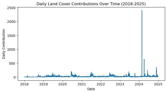
Let’s make a simple graph showing the number of contributions submitted by citizen scientists over time!
data_by_day = data[['SiteId', 'MeasuredDate']].groupby(['MeasuredDate'], as_index=False).count()

plt.figure(figsize=(8,4))
plt.plot(data_by_day['MeasuredDate'], data_by_day['SiteId'])
plt.xlabel("Date")
plt.ylabel("Daily Contribution")
plt.title("Daily Mosquito Habitat Mapper Contributions Over Time (2018-2025)")
plt.show()
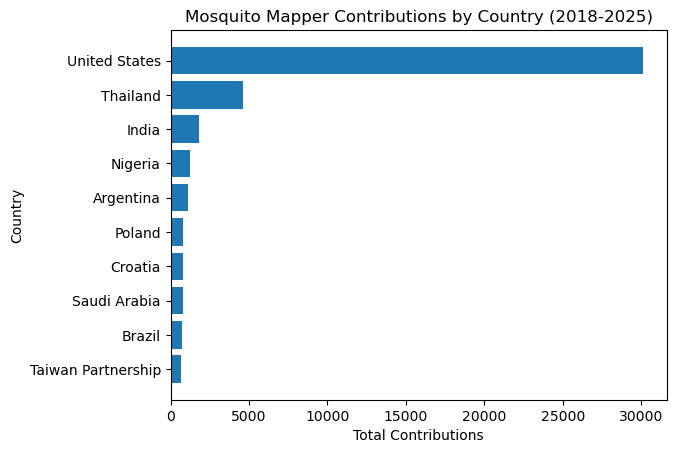
Let’s plot the number of contributions by country:
data_by_county = data[['SiteId', 'CountryName']].groupby(['CountryName'], as_index=False).count().sort_values(by='SiteId').tail(10)

plt.barh(data_by_county['CountryName'], data_by_county['SiteId'])
plt.xlabel("Total Contributions")
plt.ylabel("Country")
plt.title("Mosquito Mapper Contributions by Country (2018-2025)")
plt.show()
Land Cover#
Now, we’ll review the Land Cover dataset. In a similar way, we’ll get the data from the GLOBE API using the same date range from the Mosquito dataset.
data = gpd.read_file(f"https://api.globe.gov/search/v1/measurement/?protocols=land_covers&datefield=measuredDate&startdate=2018-01-01&enddate={end_date}&geojson=TRUE&sample=FALSE")
View a list of the columns in the dataset:
data.info()
<class 'geopandas.geodataframe.GeoDataFrame'>
RangeIndex: 52038 entries, 0 to 52037
Data columns (total 63 columns):
 #   Column                          Non-Null Count  Dtype
---  ------                          --------------  -----
 0   countryCode                     49631 non-null  object
 1   countryName                     49631 non-null  object
 2   elevation                       52038 non-null  object
 3   landcoversDataSource            52038 non-null  object
 4   landcoversDownwardCaption       52038 non-null  object
 5   landcoversDownwardExtraData     52038 non-null  object
 6   landcoversDownwardPhotoUrl      52038 non-null  object
 7   landcoversDryGround             52038 non-null  object
 8   landcoversEastCaption           52038 non-null  object
 9   landcoversEastClassifications   52038 non-null  object
 10  landcoversEastExtraData         52038 non-null  object
 11  landcoversEastPhotoUrl          52038 non-null  object
 12  landcoversFeature1Caption       52038 non-null  object
 13  landcoversFeature1ExtraData     52038 non-null  object
 14  landcoversFeature1PhotoUrl      52038 non-null  object
 15  landcoversFeature2Caption       52038 non-null  object
 16  landcoversFeature2ExtraData     52038 non-null  object
 17  landcoversFeature2PhotoUrl      52038 non-null  object
 18  landcoversFeature3Caption       52038 non-null  object
 19  landcoversFeature3ExtraData     52038 non-null  object
 20  landcoversFeature3PhotoUrl      52038 non-null  object
 21  landcoversFeature4Caption       52038 non-null  object
 22  landcoversFeature4ExtraData     52038 non-null  object
 23  landcoversFeature4PhotoUrl      52038 non-null  object
 24  landcoversFieldNotes            52038 non-null  object
 25  landcoversGlobeTeams            23991 non-null  object
 26  landcoversLandCoverId           52038 non-null  object
 27  landcoversLeavesOnTrees         52038 non-null  object
 28  landcoversLocationAccuracyM     52038 non-null  object
 29  landcoversLocationMethod        52038 non-null  object
 30  landcoversMeasuredAt            52038 non-null  datetime64[ms]
 31  landcoversMeasurementElevation  43920 non-null  object
 32  landcoversMeasurementLatitude   43920 non-null  object
 33  landcoversMeasurementLongitude  43920 non-null  object
 34  landcoversMucCode               52038 non-null  object
 35  landcoversMucDescription        52038 non-null  object
 36  landcoversMucDetails            52038 non-null  object
 37  landcoversMuddy                 52038 non-null  object
 38  landcoversNorthCaption          52038 non-null  object
 39  landcoversNorthClassifications  52038 non-null  object
 40  landcoversNorthExtraData        52038 non-null  object
 41  landcoversNorthPhotoUrl         52038 non-null  object
 42  landcoversRainingSnowing        52038 non-null  object
 43  landcoversSnowIce               52038 non-null  object
 44  landcoversSouthCaption          52038 non-null  object
 45  landcoversSouthClassifications  52038 non-null  object
 46  landcoversSouthExtraData        52038 non-null  object
 47  landcoversSouthPhotoUrl         52038 non-null  object
 48  landcoversStandingWater         52038 non-null  object
 49  landcoversUpwardCaption         52038 non-null  object
 50  landcoversUpwardExtraData       52038 non-null  object
 51  landcoversUpwardPhotoUrl        52038 non-null  object
 52  landcoversUserid                52038 non-null  object
 53  landcoversWestCaption           52038 non-null  object
 54  landcoversWestClassifications   52038 non-null  object
 55  landcoversWestExtraData         52038 non-null  object
 56  landcoversWestPhotoUrl          52038 non-null  object
 57  organizationId                  52038 non-null  object
 58  organizationName                49632 non-null  object
 59  protocol                        52038 non-null  object
 60  siteId                          52038 non-null  object
 61  siteName                        52038 non-null  object
 62  geometry                        52038 non-null  geometry
dtypes: datetime64[ms](1), geometry(1), object(61)
memory usage: 25.0+ MB
# Let's remove the "landcovers" in front of all the column names to make it easier to see the names
new_column_names = data.columns.str.replace("landcovers", "")

# Make the first letter of each column name capitalized (for consistency) except for geometry
new_column_names = [name[0].upper() + name[1:] if name != 'geometry' else name for name in new_column_names]

data.columns = new_column_names
data.info()
<class 'geopandas.geodataframe.GeoDataFrame'>
RangeIndex: 52038 entries, 0 to 52037
Data columns (total 63 columns):
 #   Column                Non-Null Count  Dtype
---  ------                --------------  -----
 0   CountryCode           49631 non-null  object
 1   CountryName           49631 non-null  object
 2   Elevation             52038 non-null  object
 3   DataSource            52038 non-null  object
 4   DownwardCaption       52038 non-null  object
 5   DownwardExtraData     52038 non-null  object
 6   DownwardPhotoUrl      52038 non-null  object
 7   DryGround             52038 non-null  object
 8   EastCaption           52038 non-null  object
 9   EastClassifications   52038 non-null  object
 10  EastExtraData         52038 non-null  object
 11  EastPhotoUrl          52038 non-null  object
 12  Feature1Caption       52038 non-null  object
 13  Feature1ExtraData     52038 non-null  object
 14  Feature1PhotoUrl      52038 non-null  object
 15  Feature2Caption       52038 non-null  object
 16  Feature2ExtraData     52038 non-null  object
 17  Feature2PhotoUrl      52038 non-null  object
 18  Feature3Caption       52038 non-null  object
 19  Feature3ExtraData     52038 non-null  object
 20  Feature3PhotoUrl      52038 non-null  object
 21  Feature4Caption       52038 non-null  object
 22  Feature4ExtraData     52038 non-null  object
 23  Feature4PhotoUrl      52038 non-null  object
 24  FieldNotes            52038 non-null  object
 25  GlobeTeams            23991 non-null  object
 26  LandCoverId           52038 non-null  object
 27  LeavesOnTrees         52038 non-null  object
 28  LocationAccuracyM     52038 non-null  object
 29  LocationMethod        52038 non-null  object
 30  MeasuredAt            52038 non-null  datetime64[ms]
 31  MeasurementElevation  43920 non-null  object
 32  MeasurementLatitude   43920 non-null  object
 33  MeasurementLongitude  43920 non-null  object
 34  MucCode               52038 non-null  object
 35  MucDescription        52038 non-null  object
 36  MucDetails            52038 non-null  object
 37  Muddy                 52038 non-null  object
 38  NorthCaption          52038 non-null  object
 39  NorthClassifications  52038 non-null  object
 40  NorthExtraData        52038 non-null  object
 41  NorthPhotoUrl         52038 non-null  object
 42  RainingSnowing        52038 non-null  object
 43  SnowIce               52038 non-null  object
 44  SouthCaption          52038 non-null  object
 45  SouthClassifications  52038 non-null  object
 46  SouthExtraData        52038 non-null  object
 47  SouthPhotoUrl         52038 non-null  object
 48  StandingWater         52038 non-null  object
 49  UpwardCaption         52038 non-null  object
 50  UpwardExtraData       52038 non-null  object
 51  UpwardPhotoUrl        52038 non-null  object
 52  Userid                52038 non-null  object
 53  WestCaption           52038 non-null  object
 54  WestClassifications   52038 non-null  object
 55  WestExtraData         52038 non-null  object
 56  WestPhotoUrl          52038 non-null  object
 57  OrganizationId        52038 non-null  object
 58  OrganizationName      49632 non-null  object
 59  Protocol              52038 non-null  object
 60  SiteId                52038 non-null  object
 61  SiteName              52038 non-null  object
 62  geometry              52038 non-null  geometry
dtypes: datetime64[ms](1), geometry(1), object(61)
memory usage: 25.0+ MB
# Add new column for date
data['MeasuredDate'] = data['MeasuredAt'].dt.date

data.head(10)
| CountryCode | CountryName | Elevation | DataSource | DownwardCaption | DownwardExtraData | DownwardPhotoUrl | DryGround | EastCaption | EastClassifications | EastExtraData | EastPhotoUrl | Feature1Caption | Feature1ExtraData | Feature1PhotoUrl | Feature2Caption | Feature2ExtraData | Feature2PhotoUrl | Feature3Caption | Feature3ExtraData | Feature3PhotoUrl | Feature4Caption | Feature4ExtraData | Feature4PhotoUrl | FieldNotes | GlobeTeams | LandCoverId | LeavesOnTrees | LocationAccuracyM | LocationMethod | MeasuredAt | MeasurementElevation | MeasurementLatitude | MeasurementLongitude | MucCode | MucDescription | MucDetails | Muddy | NorthCaption | NorthClassifications | NorthExtraData | NorthPhotoUrl | RainingSnowing | SnowIce | SouthCaption | SouthClassifications | SouthExtraData | SouthPhotoUrl | StandingWater | UpwardCaption | UpwardExtraData | UpwardPhotoUrl | Userid | WestCaption | WestClassifications | WestExtraData | WestPhotoUrl | OrganizationId | OrganizationName | Protocol | SiteId | SiteName | geometry | MeasuredDate | |
|---|---|---|---|---|---|---|---|---|---|---|---|---|---|---|---|---|---|---|---|---|---|---|---|---|---|---|---|---|---|---|---|---|---|---|---|---|---|---|---|---|---|---|---|---|---|---|---|---|---|---|---|---|---|---|---|---|---|---|---|---|---|---|---|---|
| 0 | ITA | Italy | 489.2 | GLOBE Observer App | null | null | https://data.globe.gov/system/photos/2024/12/3... | true | null | null | null | https://data.globe.gov/system/photos/2024/12/3... | Snag C. sativa, 40 cm, cl 2, #01 #04 #12 | ((compassData.heading: 182, compassData.horizo... | https://data.globe.gov/system/photos/2024/12/3... | Log 70 cm, C. sativa, cl 2, #04 #01 #12 | ((compassData.heading: 182, compassData.horizo... | https://data.globe.gov/system/photos/2024/12/3... | Stump of C. sativa 230 cm | ((compassData.heading: null, compassData.horiz... | https://data.globe.gov/system/photos/2024/12/3... | null | null | null | Old Coppice of Castanea sativa | [Conservazione Natura Universita Tuscia] | 78608 | false | 8 | automatic | 2024-12-31 15:07:00.000 | 492.4 | 42.1818 | 12.1825 | null | null | false | null | null | null | https://data.globe.gov/system/photos/2024/12/3... | false | false | null | null | null | https://data.globe.gov/system/photos/2024/12/3... | false | null | null | https://data.globe.gov/system/photos/2024/12/3... | 128342138 | null | null | null | https://data.globe.gov/system/photos/2024/12/3... | 17453129 | Italy Citizen Science | land_covers | 376869 | 33TTG673738 | POINT (12.18229 42.18175) | 2024-12-31 | |
| 1 | MDG | Madagascar | 1350.1 | GLOBE Observer App | null | null | https://data.globe.gov/system/photos/2024/12/3... | true | null | 90% MUC 01 (n) [Trees, Closely Spaced, Evergre... | null | https://data.globe.gov/system/photos/2024/12/3... | null | null | null | null | null | null | null | null | null | null | null | null | Arbres plantés par l'équipe GLOBE avec la comm... | [Africa 2024 Regional Meeting, Coordinating Of... | 77695 | true | 10 | automatic | 2024-12-31 11:29:00.000 | 1340.6 | -18.7576 | 47.5615 | M01 | Trees, Closely Spaced, Evergreen - Needle Leaved | n | false | null | 90% MUC 01 (n) [Trees, Closely Spaced, Evergre... | null | https://data.globe.gov/system/photos/2024/12/3... | false | false | null | 90% MUC 01 (n) [Trees, Closely Spaced, Evergre... | null | https://data.globe.gov/system/photos/2024/12/3... | false | null | null | https://data.globe.gov/system/photos/2024/12/3... | 2538037 | null | 90% MUC 01 (n) [Trees, Closely Spaced, Evergre... | null | https://data.globe.gov/system/photos/2024/12/3... | 6508873 | Madagascar GLOBE v-School | land_covers | 373647 | 38KQE700240 | POINT (47.56096 -18.75807) | 2024-12-31 |
| 2 | MDG | Madagascar | 1324.7 | GLOBE Observer App | null | null | https://data.globe.gov/system/photos/2024/12/3... | true | null | 60% MUC 93 [Urban, Roads and Parking] | null | https://data.globe.gov/system/photos/2024/12/3... | null | null | null | null | null | null | null | null | null | null | null | null | (none) | [Africa 2024 Regional Meeting, Coordinating Of... | 77691 | true | 10 | automatic | 2024-12-31 12:07:00.000 | 1324.8 | -18.7944 | 47.5799 | M93 | Urban, Roads and Parking | false | null | 60% MUC 93 [Urban, Roads and Parking] | null | https://data.globe.gov/system/photos/2024/12/3... | false | false | null | 60% MUC 93 [Urban, Roads and Parking] | null | https://data.globe.gov/system/photos/2024/12/3... | false | null | null | https://data.globe.gov/system/photos/2024/12/3... | 2538037 | null | 60% MUC 93 [Urban, Roads and Parking] | null | https://data.globe.gov/system/photos/2024/12/3... | 6508873 | Madagascar GLOBE v-School | land_covers | 373642 | 38KQE719199 | POINT (47.57953 -18.79484) | 2024-12-31 | |
| 3 | USA | United States | 182.2 | GLOBE Data Entry Site Definition | null | null | null | null | null | null | null | null | null | null | null | null | null | null | null | null | null | null | null | null | null | None | 77689 | null | null | null | 2024-12-31 16:12:03.111 | None | None | None | M4 | Herbaceous Vegetation | null | null | null | null | null | null | null | null | null | null | null | null | null | null | null | null | null | null | null | null | null | 52107 | Crestwood High School | land_covers | 373628 | Hillcrest Elementary Trail | POINT (-83.27705 42.3465) | 2024-12-31 |
| 4 | GRC | Greece | 3.0 | GLOBE Observer App | null | null | https://data.globe.gov/system/photos/2024/12/3... | true | null | 90% MUC 91 [Urban, Residential Property]; 10% ... | null | https://data.globe.gov/system/photos/2024/12/3... | null | null | null | null | null | null | null | null | null | null | null | null | (none) | [tinycore lab, tinycorelab] | 77683 | false | null | manual | 2024-12-31 11:45:00.000 | 3.2 | 37.939 | 23.697 | M91 | Urban, Residential Property | false | null | 90% MUC 91 [Urban, Residential Property]; 10% ... | null | https://data.globe.gov/system/photos/2024/12/3... | false | false | null | 20% MUC 91 [Urban, Residential Property]; 80% ... | null | https://data.globe.gov/system/photos/2024/12/3... | false | null | null | https://data.globe.gov/system/photos/2024/12/3... | 65209921 | null | 10% MUC 91 [Urban, Residential Property]; 90% ... | null | https://data.globe.gov/system/photos/2024/12/3... | 6508393 | Greece GLOBE v-School | land_covers | 373613 | 34SGH370024 | POINT (23.6969 37.9383) | 2024-12-31 | |
| 5 | GRC | Greece | 15.5 | GLOBE Observer App | null | null | https://data.globe.gov/system/photos/2024/12/3... | true | null | 40% MUC 94 [Urban, Other]; 60% MUC 43 [Herbace... | null | https://data.globe.gov/system/photos/2024/12/3... | Park | ((compassData.heading: 137, compassData.horizo... | https://data.globe.gov/system/photos/2024/12/3... | null | null | null | null | null | null | null | null | null | (none) | [tinycore lab, tinycorelab] | 77681 | false | null | manual | 2024-12-31 11:01:00.000 | 16.7 | 37.9374 | 23.7051 | M43 | Herbaceous/Grassland, Short Grass | true | null | 10% MUC 94 [Urban, Other]; 90% MUC 43 [Herbace... | null | https://data.globe.gov/system/photos/2024/12/3... | false | false | null | 40% MUC 94 [Urban, Other]; 60% MUC 43 [Herbace... | null | https://data.globe.gov/system/photos/2024/12/3... | false | null | null | https://data.globe.gov/system/photos/2024/12/3... | 65209921 | null | 10% MUC 94 [Urban, Other]; 90% MUC 43 [Herbace... | null | https://data.globe.gov/system/photos/2024/12/3... | 6508393 | Greece GLOBE v-School | land_covers | 373609 | 34SGH377023 | POINT (23.70482 37.93722) | 2024-12-31 | |
| 6 | MDG | Madagascar | 1303.5 | GLOBE Observer App | null | null | https://data.globe.gov/system/photos/2024/12/3... | true | null | null | null | https://data.globe.gov/system/photos/2024/12/3... | null | null | null | null | null | null | null | null | null | null | null | null | (none) | [Africa 2024 Regional Meeting, Coordinating Of... | 77692 | true | 7 | automatic | 2024-12-31 11:53:00.000 | 1337.6 | -18.7639 | 47.5584 | M01 | Trees, Closely Spaced, Evergreen - Needle Leaved | n | false | null | 50% MUC 01 (n) [Trees, Closely Spaced, Evergre... | null | https://data.globe.gov/system/photos/2024/12/3... | false | false | null | null | null | https://data.globe.gov/system/photos/2024/12/3... | false | null | null | https://data.globe.gov/system/photos/2024/12/3... | 2538037 | null | null | null | https://data.globe.gov/system/photos/2024/12/3... | 6508873 | Madagascar GLOBE v-School | land_covers | 373644 | 38KQE697233 | POINT (47.55822 -18.76443) | 2024-12-31 |
| 7 | ITA | Italy | 440.2 | GLOBE Observer App | null | null | https://data.globe.gov/system/photos/2024/12/3... | true | null | null | null | https://data.globe.gov/system/photos/2024/12/3... | snag F. sylvatica 140 cm, cl 1, #4 #12 | ((compassData.heading: 174, compassData.horizo... | https://data.globe.gov/system/photos/2024/12/3... | Log F. sylvatica90 cm, cl2, #1 #4 #12 #14 | ((compassData.heading: 174, compassData.horizo... | https://data.globe.gov/system/photos/2024/12/3... | null | null | null | null | null | null | Old high forest of Fagus sylvatica | [Conservazione Natura Universita Tuscia] | 78607 | false | 12 | automatic | 2024-12-31 14:07:00.000 | 447.3 | 42.1797 | 12.1754 | null | null | false | null | null | null | https://data.globe.gov/system/photos/2024/12/3... | false | false | null | null | null | https://data.globe.gov/system/photos/2024/12/3... | false | null | null | https://data.globe.gov/system/photos/2024/12/3... | 128342138 | null | null | null | https://data.globe.gov/system/photos/2024/12/3... | 17453129 | Italy Citizen Science | land_covers | 373629 | 33TTG667735 | POINT (12.17516 42.17887) | 2024-12-31 | |
| 8 | MDG | Madagascar | 1461.9 | GLOBE Observer App | null | null | https://data.globe.gov/system/photos/2024/12/3... | true | null | 80% MUC 94 [Urban, Other] | null | https://data.globe.gov/system/photos/2024/12/3... | null | null | null | null | null | null | null | null | null | null | null | null | (none) | [Africa 2024 Regional Meeting, Coordinating Of... | 77686 | false | 6 | automatic | 2024-12-31 10:57:00.000 | 1463.8 | -18.7605 | 47.563 | M94 | Urban, Other | false | null | 80% MUC 94 [Urban, Other] | null | https://data.globe.gov/system/photos/2024/12/3... | false | false | null | 80% MUC 94 [Urban, Other] | null | https://data.globe.gov/system/photos/2024/12/3... | false | null | null | https://data.globe.gov/system/photos/2024/12/3... | 2538037 | null | 80% MUC 94 [Urban, Other] | null | https://data.globe.gov/system/photos/2024/12/3... | 6508873 | Madagascar GLOBE v-School | land_covers | 373618 | 38KQE702237 | POINT (47.5629 -18.76075) | 2024-12-31 | |
| 9 | MDG | Madagascar | 1450.3 | GLOBE Observer App | null | null | https://data.globe.gov/system/photos/2024/12/3... | true | null | 50% MUC 94 [Urban, Other] | null | https://data.globe.gov/system/photos/2024/12/3... | null | null | null | null | null | null | null | null | null | null | null | null | (none) | [Africa 2024 Regional Meeting, Coordinating Of... | 77696 | false | 8 | automatic | 2024-12-31 11:13:00.000 | 1455.8 | -18.7607 | 47.5623 | M94 | Urban, Other | false | null | 50% MUC 94 [Urban, Other] | null | https://data.globe.gov/system/photos/2024/12/3... | false | false | null | 50% MUC 94 [Urban, Other] | null | https://data.globe.gov/system/photos/2024/12/3... | false | null | null | https://data.globe.gov/system/photos/2024/12/3... | 2538037 | null | 50% MUC 94 [Urban, Other] | null | https://data.globe.gov/system/photos/2024/12/3... | 6508873 | Madagascar GLOBE v-School | land_covers | 373617 | 38KQE701237 | POINT (47.56195 -18.76076) | 2024-12-31 |
Replace null values:
data['FieldNotes'] = data['FieldNotes'].replace('(none)', np.nan)
data = data.replace('null', np.nan)
data.info()
<class 'geopandas.geodataframe.GeoDataFrame'>
RangeIndex: 52038 entries, 0 to 52037
Data columns (total 64 columns):
 #   Column                Non-Null Count  Dtype
---  ------                --------------  -----
 0   CountryCode           49631 non-null  object
 1   CountryName           49631 non-null  object
 2   Elevation             52038 non-null  object
 3   DataSource            52038 non-null  object
 4   DownwardCaption       22648 non-null  object
 5   DownwardExtraData     22644 non-null  object
 6   DownwardPhotoUrl      40040 non-null  object
 7   DryGround             43973 non-null  object
 8   EastCaption           23889 non-null  object
 9   EastClassifications   14465 non-null  object
 10  EastExtraData         23884 non-null  object
 11  EastPhotoUrl          42897 non-null  object
 12  Feature1Caption       341 non-null    object
 13  Feature1ExtraData     1389 non-null   object
 14  Feature1PhotoUrl      1390 non-null   object
 15  Feature2Caption       158 non-null    object
 16  Feature2ExtraData     694 non-null    object
 17  Feature2PhotoUrl      694 non-null    object
 18  Feature3Caption       98 non-null     object
 19  Feature3ExtraData     463 non-null    object
 20  Feature3PhotoUrl      463 non-null    object
 21  Feature4Caption       78 non-null     object
 22  Feature4ExtraData     347 non-null    object
 23  Feature4PhotoUrl      347 non-null    object
 24  FieldNotes            21884 non-null  object
 25  GlobeTeams            23991 non-null  object
 26  LandCoverId           52038 non-null  object
 27  LeavesOnTrees         43973 non-null  object
 28  LocationAccuracyM     36779 non-null  object
 29  LocationMethod        43973 non-null  object
 30  MeasuredAt            52038 non-null  datetime64[ms]
 31  MeasurementElevation  43920 non-null  object
 32  MeasurementLatitude   43920 non-null  object
 33  MeasurementLongitude  43920 non-null  object
 34  MucCode               22725 non-null  object
 35  MucDescription        22722 non-null  object
 36  MucDetails            43973 non-null  object
 37  Muddy                 43973 non-null  object
 38  NorthCaption          24182 non-null  object
 39  NorthClassifications  14498 non-null  object
 40  NorthExtraData        24182 non-null  object
 41  NorthPhotoUrl         43276 non-null  object
 42  RainingSnowing        43973 non-null  object
 43  SnowIce               43973 non-null  object
 44  SouthCaption          23750 non-null  object
 45  SouthClassifications  14463 non-null  object
 46  SouthExtraData        23748 non-null  object
 47  SouthPhotoUrl         42782 non-null  object
 48  StandingWater         43973 non-null  object
 49  UpwardCaption         23150 non-null  object
 50  UpwardExtraData       23143 non-null  object
 51  UpwardPhotoUrl        40807 non-null  object
 52  Userid                43973 non-null  object
 53  WestCaption           23718 non-null  object
 54  WestClassifications   14438 non-null  object
 55  WestExtraData         23728 non-null  object
 56  WestPhotoUrl          42689 non-null  object
 57  OrganizationId        49632 non-null  object
 58  OrganizationName      49632 non-null  object
 59  Protocol              52038 non-null  object
 60  SiteId                52038 non-null  object
 61  SiteName              52038 non-null  object
 62  geometry              52038 non-null  geometry
 63  MeasuredDate          52038 non-null  object
dtypes: datetime64[ms](1), geometry(1), object(62)
memory usage: 25.4+ MB
Similar to the mosquito dataset, we will filter out any points that do not fall within country boundaries. If the point is over water, then we assume the coordinates were incorrectly reported and remove it from the final dataset.
data = gpd.sjoin(data, countries, how="inner", predicate='intersects') \
          .drop(columns=['index_right', 'COUNTRY']) \
          .reset_index(drop=True)
data
| CountryCode | CountryName | Elevation | DataSource | DownwardCaption | DownwardExtraData | DownwardPhotoUrl | DryGround | EastCaption | EastClassifications | EastExtraData | EastPhotoUrl | Feature1Caption | Feature1ExtraData | Feature1PhotoUrl | Feature2Caption | Feature2ExtraData | Feature2PhotoUrl | Feature3Caption | Feature3ExtraData | Feature3PhotoUrl | Feature4Caption | Feature4ExtraData | Feature4PhotoUrl | FieldNotes | GlobeTeams | LandCoverId | LeavesOnTrees | LocationAccuracyM | LocationMethod | MeasuredAt | MeasurementElevation | MeasurementLatitude | MeasurementLongitude | MucCode | MucDescription | MucDetails | Muddy | NorthCaption | NorthClassifications | NorthExtraData | NorthPhotoUrl | RainingSnowing | SnowIce | SouthCaption | SouthClassifications | SouthExtraData | SouthPhotoUrl | StandingWater | UpwardCaption | UpwardExtraData | UpwardPhotoUrl | Userid | WestCaption | WestClassifications | WestExtraData | WestPhotoUrl | OrganizationId | OrganizationName | Protocol | SiteId | SiteName | geometry | MeasuredDate | |
|---|---|---|---|---|---|---|---|---|---|---|---|---|---|---|---|---|---|---|---|---|---|---|---|---|---|---|---|---|---|---|---|---|---|---|---|---|---|---|---|---|---|---|---|---|---|---|---|---|---|---|---|---|---|---|---|---|---|---|---|---|---|---|---|---|
| 0 | ITA | Italy | 489.2 | GLOBE Observer App | NaN | NaN | https://data.globe.gov/system/photos/2024/12/3... | true | NaN | NaN | NaN | https://data.globe.gov/system/photos/2024/12/3... | Snag C. sativa, 40 cm, cl 2, #01 #04 #12 | ((compassData.heading: 182, compassData.horizo... | https://data.globe.gov/system/photos/2024/12/3... | Log 70 cm, C. sativa, cl 2, #04 #01 #12 | ((compassData.heading: 182, compassData.horizo... | https://data.globe.gov/system/photos/2024/12/3... | Stump of C. sativa 230 cm | ((compassData.heading: null, compassData.horiz... | https://data.globe.gov/system/photos/2024/12/3... | NaN | NaN | NaN | Old Coppice of Castanea sativa | [Conservazione Natura Universita Tuscia] | 78608 | false | 8 | automatic | 2024-12-31 15:07:00.000 | 492.4 | 42.1818 | 12.1825 | NaN | NaN | false | NaN | NaN | NaN | https://data.globe.gov/system/photos/2024/12/3... | false | false | NaN | NaN | NaN | https://data.globe.gov/system/photos/2024/12/3... | false | NaN | NaN | https://data.globe.gov/system/photos/2024/12/3... | 128342138 | NaN | NaN | NaN | https://data.globe.gov/system/photos/2024/12/3... | 17453129 | Italy Citizen Science | land_covers | 376869 | 33TTG673738 | POINT (12.18229 42.18175) | 2024-12-31 | |
| 1 | MDG | Madagascar | 1350.1 | GLOBE Observer App | NaN | NaN | https://data.globe.gov/system/photos/2024/12/3... | true | NaN | 90% MUC 01 (n) [Trees, Closely Spaced, Evergre... | NaN | https://data.globe.gov/system/photos/2024/12/3... | NaN | NaN | NaN | NaN | NaN | NaN | NaN | NaN | NaN | NaN | NaN | NaN | Arbres plantés par l'équipe GLOBE avec la comm... | [Africa 2024 Regional Meeting, Coordinating Of... | 77695 | true | 10 | automatic | 2024-12-31 11:29:00.000 | 1340.6 | -18.7576 | 47.5615 | M01 | Trees, Closely Spaced, Evergreen - Needle Leaved | n | false | NaN | 90% MUC 01 (n) [Trees, Closely Spaced, Evergre... | NaN | https://data.globe.gov/system/photos/2024/12/3... | false | false | NaN | 90% MUC 01 (n) [Trees, Closely Spaced, Evergre... | NaN | https://data.globe.gov/system/photos/2024/12/3... | false | NaN | NaN | https://data.globe.gov/system/photos/2024/12/3... | 2538037 | NaN | 90% MUC 01 (n) [Trees, Closely Spaced, Evergre... | NaN | https://data.globe.gov/system/photos/2024/12/3... | 6508873 | Madagascar GLOBE v-School | land_covers | 373647 | 38KQE700240 | POINT (47.56096 -18.75807) | 2024-12-31 |
| 2 | MDG | Madagascar | 1324.7 | GLOBE Observer App | NaN | NaN | https://data.globe.gov/system/photos/2024/12/3... | true | NaN | 60% MUC 93 [Urban, Roads and Parking] | NaN | https://data.globe.gov/system/photos/2024/12/3... | NaN | NaN | NaN | NaN | NaN | NaN | NaN | NaN | NaN | NaN | NaN | NaN | NaN | [Africa 2024 Regional Meeting, Coordinating Of... | 77691 | true | 10 | automatic | 2024-12-31 12:07:00.000 | 1324.8 | -18.7944 | 47.5799 | M93 | Urban, Roads and Parking | false | NaN | 60% MUC 93 [Urban, Roads and Parking] | NaN | https://data.globe.gov/system/photos/2024/12/3... | false | false | NaN | 60% MUC 93 [Urban, Roads and Parking] | NaN | https://data.globe.gov/system/photos/2024/12/3... | false | NaN | NaN | https://data.globe.gov/system/photos/2024/12/3... | 2538037 | NaN | 60% MUC 93 [Urban, Roads and Parking] | NaN | https://data.globe.gov/system/photos/2024/12/3... | 6508873 | Madagascar GLOBE v-School | land_covers | 373642 | 38KQE719199 | POINT (47.57953 -18.79484) | 2024-12-31 | |
| 3 | USA | United States | 182.2 | GLOBE Data Entry Site Definition | NaN | NaN | NaN | NaN | NaN | NaN | NaN | NaN | NaN | NaN | NaN | NaN | NaN | NaN | NaN | NaN | NaN | NaN | NaN | NaN | NaN | None | 77689 | NaN | NaN | NaN | 2024-12-31 16:12:03.111 | None | None | None | M4 | Herbaceous Vegetation | NaN | NaN | NaN | NaN | NaN | NaN | NaN | NaN | NaN | NaN | NaN | NaN | NaN | NaN | NaN | NaN | NaN | NaN | NaN | NaN | NaN | 52107 | Crestwood High School | land_covers | 373628 | Hillcrest Elementary Trail | POINT (-83.27705 42.3465) | 2024-12-31 |
| 4 | GRC | Greece | 3.0 | GLOBE Observer App | NaN | NaN | https://data.globe.gov/system/photos/2024/12/3... | true | NaN | 90% MUC 91 [Urban, Residential Property]; 10% ... | NaN | https://data.globe.gov/system/photos/2024/12/3... | NaN | NaN | NaN | NaN | NaN | NaN | NaN | NaN | NaN | NaN | NaN | NaN | NaN | [tinycore lab, tinycorelab] | 77683 | false | NaN | manual | 2024-12-31 11:45:00.000 | 3.2 | 37.939 | 23.697 | M91 | Urban, Residential Property | false | NaN | 90% MUC 91 [Urban, Residential Property]; 10% ... | NaN | https://data.globe.gov/system/photos/2024/12/3... | false | false | NaN | 20% MUC 91 [Urban, Residential Property]; 80% ... | NaN | https://data.globe.gov/system/photos/2024/12/3... | false | NaN | NaN | https://data.globe.gov/system/photos/2024/12/3... | 65209921 | NaN | 10% MUC 91 [Urban, Residential Property]; 90% ... | NaN | https://data.globe.gov/system/photos/2024/12/3... | 6508393 | Greece GLOBE v-School | land_covers | 373613 | 34SGH370024 | POINT (23.6969 37.9383) | 2024-12-31 | |
| ... | ... | ... | ... | ... | ... | ... | ... | ... | ... | ... | ... | ... | ... | ... | ... | ... | ... | ... | ... | ... | ... | ... | ... | ... | ... | ... | ... | ... | ... | ... | ... | ... | ... | ... | ... | ... | ... | ... | ... | ... | ... | ... | ... | ... | ... | ... | ... | ... | ... | ... | ... | ... | ... | ... | ... | ... | ... | ... | ... | ... | ... | ... | ... | ... |
| 50778 | OMN | Oman | 584.0 | GLOBE Data Entry Site Definition | NaN | NaN | NaN | NaN | NaN | NaN | NaN | NaN | NaN | NaN | NaN | NaN | NaN | NaN | NaN | NaN | NaN | NaN | NaN | NaN | NaN | None | 20324 | NaN | NaN | NaN | 2018-01-16 12:52:15.524 | None | None | None | M823 | Cultivated Land, Non-Agriculture, Cemeteries | NaN | NaN | NaN | NaN | NaN | NaN | NaN | NaN | NaN | NaN | NaN | NaN | NaN | NaN | NaN | NaN | NaN | NaN | NaN | NaN | NaN | 23062994 | Elayet feda basic school | land_covers | 104390 | yanqul park | POINT (56.43 23.43) | 2018-01-16 |
| 50779 | HRV | Croatia | 153.0 | GLOBE Data Entry Site Definition | NaN | NaN | NaN | NaN | NaN | NaN | NaN | NaN | NaN | NaN | NaN | NaN | NaN | NaN | NaN | NaN | NaN | NaN | NaN | NaN | NaN | None | 20326 | NaN | NaN | NaN | 2018-01-16 20:19:21.378 | None | None | None | M1211 | Woodland, Mainly Deciduous, Drought-Deciduous,... | NaN | NaN | NaN | NaN | NaN | NaN | NaN | NaN | NaN | NaN | NaN | NaN | NaN | NaN | NaN | NaN | NaN | NaN | NaN | NaN | NaN | 177974 | II. osnovna skola Cakovec | land_covers | 104405 | Žabnik- Sv. Martin | POINT (16.377 46.528) | 2018-01-16 |
| 50780 | OMN | Oman | 27.0 | GLOBE Data Entry Site Definition | NaN | NaN | NaN | NaN | NaN | NaN | NaN | NaN | NaN | NaN | NaN | NaN | NaN | NaN | NaN | NaN | NaN | NaN | NaN | NaN | NaN | None | 20321 | NaN | NaN | NaN | 2018-01-03 21:57:54.342 | None | None | None | M812 | Cultivated Land, Agriculture, Orchard and Hort... | NaN | NaN | NaN | NaN | NaN | NaN | NaN | NaN | NaN | NaN | NaN | NaN | NaN | NaN | NaN | NaN | NaN | NaN | NaN | NaN | NaN | 23061684 | Al duqom basic school | land_covers | 101771 | ALduqm shcool | POINT (57.37 19.37) | 2018-01-03 |
| 50781 | OMN | Oman | 27.0 | GLOBE Data Entry Site Definition | NaN | NaN | NaN | NaN | NaN | NaN | NaN | NaN | NaN | NaN | NaN | NaN | NaN | NaN | NaN | NaN | NaN | NaN | NaN | NaN | NaN | None | 20322 | NaN | NaN | NaN | 2018-01-03 22:00:19.250 | None | None | None | M812 | Cultivated Land, Agriculture, Orchard and Hort... | NaN | NaN | NaN | NaN | NaN | NaN | NaN | NaN | NaN | NaN | NaN | NaN | NaN | NaN | NaN | NaN | NaN | NaN | NaN | NaN | NaN | 23061684 | Al duqom basic school | land_covers | 101771 | ALduqm shcool | POINT (57.37 19.37) | 2018-01-03 |
| 50782 | OMN | Oman | 0.0 | GLOBE Data Entry Site Definition | NaN | NaN | NaN | NaN | NaN | NaN | NaN | NaN | NaN | NaN | NaN | NaN | NaN | NaN | NaN | NaN | NaN | NaN | NaN | NaN | NaN | None | 20320 | NaN | NaN | NaN | 2018-01-01 08:47:12.483 | None | None | None | M8 | Cultivated Land | NaN | NaN | NaN | NaN | NaN | NaN | NaN | NaN | NaN | NaN | NaN | NaN | NaN | NaN | NaN | NaN | NaN | NaN | NaN | NaN | NaN | 36736232 | Madira Pasic School | land_covers | 104036 | MADERA BASIC SCHOOL | POINT (58.167 21.0717) | 2018-01-01 |
50783 rows × 64 columns
Like the mosquito data, a copy of this dataset is on GitHub, and we will use this in future chapters. You do not need to download the dataset to your computer, as we will load the data directly using the link.
Explore the Data#
data_by_day = data[['SiteId', 'MeasuredDate']].groupby(['MeasuredDate'], as_index=False).count()

plt.figure(figsize=(8,4))
plt.plot(data_by_day['MeasuredDate'], data_by_day['SiteId'])
plt.xlabel("Date")
plt.ylabel("Daily Contribution")
plt.title("Daily Land Cover Contributions Over Time (2018-2025)")
plt.show()
data_by_county = data[['SiteId', 'CountryName']].groupby(['CountryName'], as_index=False).count().sort_values(by='SiteId').tail(10)

plt.barh(data_by_county['CountryName'], data_by_county['SiteId'])
plt.xlabel("Total Contributions")
plt.ylabel("Country")
plt.title("Mosquito Mapper Contributions by Country (2018-2025)")
plt.show()
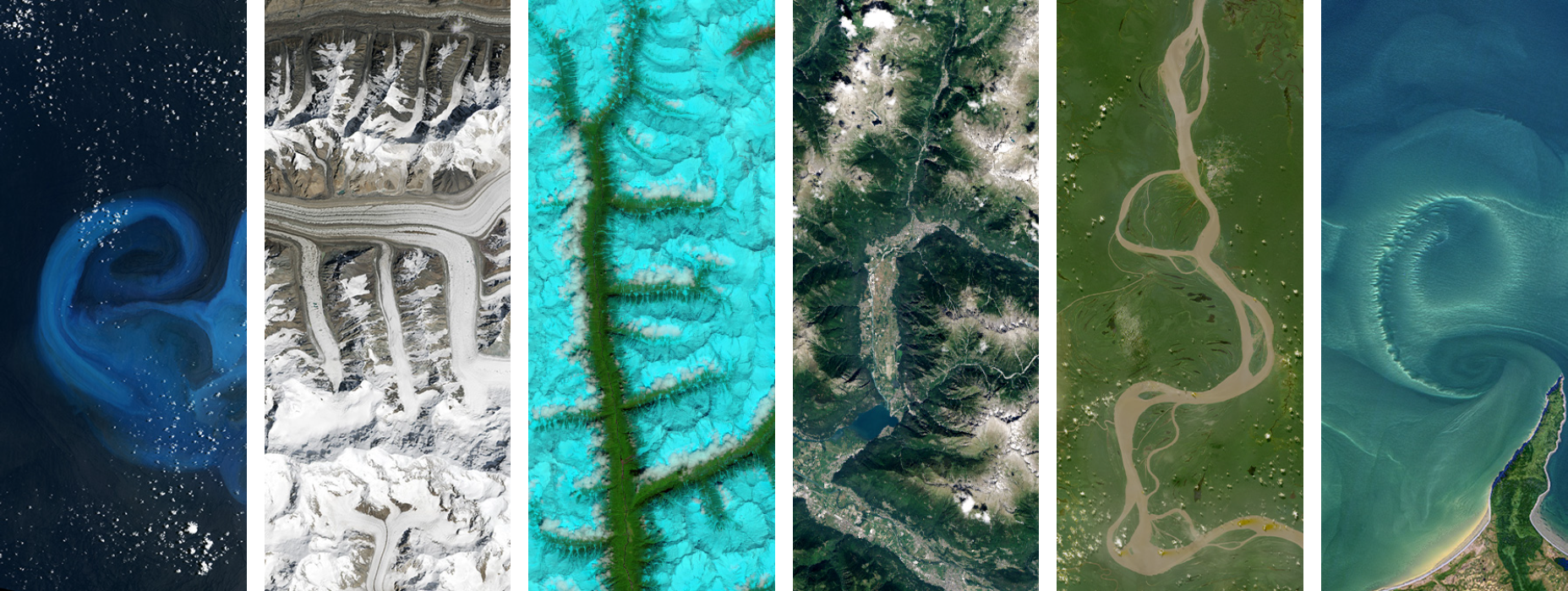
A powerful feature of the Land Cover dataset is that users submit pictures of the area. Let’s view some of these images.
# Get the first observation where all photos were submitted
entry = data.dropna(subset=['DownwardPhotoUrl', 'EastPhotoUrl', 'NorthPhotoUrl', 'SouthPhotoUrl', 'WestPhotoUrl', 'UpwardPhotoUrl',
                            'Feature1PhotoUrl', 'Feature2PhotoUrl', 'Feature3PhotoUrl', 'Feature4PhotoUrl']).head(1)

url_list = []
col_list = []

for col in entry.columns:
  if 'Url' in col:
    print(f'{col}: {entry[col].values[0]}')
    url_list.append(entry[col].values[0])
    col_list.append(col)

display(entry)
DownwardPhotoUrl: https://data.globe.gov/system/photos/2024/12/31/4325699/original.jpg
EastPhotoUrl: https://data.globe.gov/system/photos/2024/12/31/4325695/original.jpg
Feature1PhotoUrl: https://data.globe.gov/system/photos/2024/12/31/4325700/original.jpg
Feature2PhotoUrl: https://data.globe.gov/system/photos/2024/12/31/4325701/original.jpg
Feature3PhotoUrl: https://data.globe.gov/system/photos/2024/12/31/4325702/original.jpg
Feature4PhotoUrl: https://data.globe.gov/system/photos/2024/12/31/4325703/original.jpg
NorthPhotoUrl: https://data.globe.gov/system/photos/2024/12/31/4325694/original.jpg
SouthPhotoUrl: https://data.globe.gov/system/photos/2024/12/31/4325696/original.jpg
UpwardPhotoUrl: https://data.globe.gov/system/photos/2024/12/31/4325698/original.jpg
WestPhotoUrl: https://data.globe.gov/system/photos/2024/12/31/4325697/original.jpg
| CountryCode | CountryName | Elevation | DataSource | DownwardCaption | DownwardExtraData | DownwardPhotoUrl | DryGround | EastCaption | EastClassifications | EastExtraData | EastPhotoUrl | Feature1Caption | Feature1ExtraData | Feature1PhotoUrl | Feature2Caption | Feature2ExtraData | Feature2PhotoUrl | Feature3Caption | Feature3ExtraData | Feature3PhotoUrl | Feature4Caption | Feature4ExtraData | Feature4PhotoUrl | FieldNotes | GlobeTeams | LandCoverId | LeavesOnTrees | LocationAccuracyM | LocationMethod | MeasuredAt | MeasurementElevation | MeasurementLatitude | MeasurementLongitude | MucCode | MucDescription | MucDetails | Muddy | NorthCaption | NorthClassifications | NorthExtraData | NorthPhotoUrl | RainingSnowing | SnowIce | SouthCaption | SouthClassifications | SouthExtraData | SouthPhotoUrl | StandingWater | UpwardCaption | UpwardExtraData | UpwardPhotoUrl | Userid | WestCaption | WestClassifications | WestExtraData | WestPhotoUrl | OrganizationId | OrganizationName | Protocol | SiteId | SiteName | geometry | MeasuredDate | |
|---|---|---|---|---|---|---|---|---|---|---|---|---|---|---|---|---|---|---|---|---|---|---|---|---|---|---|---|---|---|---|---|---|---|---|---|---|---|---|---|---|---|---|---|---|---|---|---|---|---|---|---|---|---|---|---|---|---|---|---|---|---|---|---|---|
| 11 | ITA | Italy | 1076.2 | GLOBE Observer App | NaN | NaN | https://data.globe.gov/system/photos/2024/12/3... | false | NaN | 90% MUC 12 (b) [Trees, Loosely Spaced, Deciduo... | NaN | https://data.globe.gov/system/photos/2024/12/3... | NaN | ((compassData.heading: 328, compassData.horizo... | https://data.globe.gov/system/photos/2024/12/3... | NaN | ((compassData.heading: 68, compassData.horizon... | https://data.globe.gov/system/photos/2024/12/3... | NaN | ((compassData.heading: 80, compassData.horizon... | https://data.globe.gov/system/photos/2024/12/3... | NaN | ((compassData.heading: 118, compassData.horizo... | https://data.globe.gov/system/photos/2024/12/3... | Buca in fustaia coetanea di faggio a dominanza... | [Conservazione Natura Universita Tuscia] | 78265 | false | 4 | automatic | 2024-12-31 10:47:00 | 1062.4 | 41.7648 | 14.2258 | M12 | Trees, Loosely Spaced, Deciduous - Broad Leaved | b | false | NaN | 90% MUC 12 (b) [Trees, Loosely Spaced, Deciduo... | NaN | https://data.globe.gov/system/photos/2024/12/3... | false | true | NaN | 90% MUC 12 (b) [Trees, Loosely Spaced, Deciduo... | NaN | https://data.globe.gov/system/photos/2024/12/3... | false | NaN | NaN | https://data.globe.gov/system/photos/2024/12/3... | 140413632 | NaN | 90% MUC 12 (b) [Trees, Loosely Spaced, Deciduo... | NaN | https://data.globe.gov/system/photos/2024/12/3... | 17453129 | Italy Citizen Science | land_covers | 375492 | 33TVG356239 | POINT (14.22524 41.76432) | 2024-12-31 |
# Plot all of the images
plt.figure(figsize=(20, 6))

for i, (url, title) in enumerate(zip(url_list, col_list)):
    response = requests.get(url)
    img = Image.open(BytesIO(response.content))

    # Create plot with 2 rows, 5 columns
    plt.subplot(2, 5, i + 1)
    plt.imshow(img)
    plt.title(title)
    plt.axis('off')

plt.tight_layout()
plt.show()
